Water, water, everywhere. I’ve lived in California since 1978 and I’ve never seen the north state so saturated with rain and runoff. The floods of 1997 have already been surpassed, at least in my mind, and the bad news is there’s more rain on the way, a series of powerful storms—so-called atmospheric rivers—that threaten to drown interior northern California and reveal yet more cracks in the state’s aging infrastructure.
As I write this on Sun., Feb. 19, the National Weather Service has issued flood warnings through 4 p.m. Thursday for Alpine, Amador Butte Calaveras, Colusa, El Dorado, Glenn, Lake, Lassen, Nevada, Placer, Plumas, Sacramento, San Joaquin, Shasta, Sierra, Solano, Stanislaus, Sutter, Tehama Tuolumne, Yolo and Yuba counties.
“Interior northern California will experience another significant uptick in flooding problems… as an intense atmospheric river type storm arrives,” the weather service warns. “Our entire region has saturated soils and many flooded areas already. This will enhance the impact of additional heavy rains this week. Additional stress will be placed on levees, rivers, creeks and streams. We may see flooding in locations which haven’t been impacted in many years. We are strongly advising all residents in interior northern California to be prepared for flooding.”
The weather service advises residents to be prepared to evacuate at any time and suggests gathering together a go-bag with important items like medications and hard to replace documents.
“Do not forget to plan for your pets and animals,” the warning continues. “Please never drive across flooded waters and roadways, especially flowing waters. Most people who are killed are injured during floods are attempting to drive through flooded waters. Turn around, don’t drown!”
It’s a strident warning that anyone in the lowlands should heed as if their life is at stake, because potentially it is. I feel relatively safe 2500 feet up in the foothills of eastern Shasta County—our one problem creek is under control now—but there are a lot of big trees growing in soft, saturated earth on the hillside next to my house, and high winds are forecast as well. All this wet winter long I’ve been listening to the rain drumming on the roof and tapping on the windows, waiting for the howling wind to take down one of the trees. But that’s just me being paranoid. It’s the lowlands where the real trouble is.
I found that out for myself earlier this month, driving from Whitmore to Sacramento, 220 miles south on I-5, on one of the darkest mornings I can recall, through driving rain and infrequent flashes of sheet lightening, across flooded rice fields and the swollen north end of the Yolo Bypass just past Woodland, which looked more like an inland sea than a piece of the Sacramento River’s built-in flood infrastructure, a vast lake extending all the way to the Sacramento-San Joaquin Delta, where I used to live once-upon-a-time.
I’ve never seen the bypass so full and today, two weeks of pretty much constant rain later, many of the towns along I-5 and the Sacramento River north of the bypass, including Colusa, Maxwell and Williams, are under water.
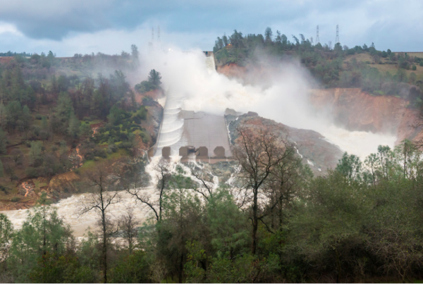
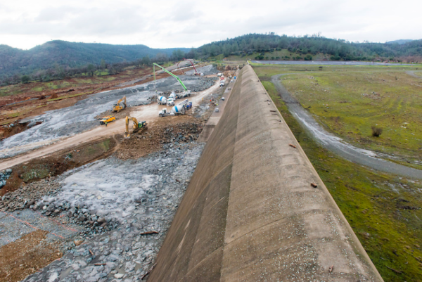
The day after I returned from my Sacramento trip — Feb. 7 — a hole the size of a dump truck was discovered in the Orville Dam’s spillway. My father is a retired United States Bureau of Reclamation power plant operator, I grew up on state and federal water projects, so we perhaps paid more attention than most people, especially when officials announced on Feb. 11 that after further damage to the spillway, they were shutting it down and, for the first time ever, using the auxiliary spillway.
The following afternoon, Feb. 12, I turned on the TV and saw a red scrawl across the bottom of the screen warning anyone in the path of the Oroville Dam to evacuate immediately due to imminent failure of the dam. My parents live right next door, and I ran over to tell Dad the news.
We turned on his much-bigger TV and watched in genuine horror after we found footage of Lake Oroville topping the 770-foot-high dam, cascading almost elegantly over the auxiliary spillway’s concrete lip, and then, as water is wont to do, boring into the tree-studded earthen hillside, carrying away dirt and an access road, threatening to undermine the auxiliary spillway and send a 30-foot-tall wall of water sloshing across the already water-logged northern Sacramento Valley.
Officials did the only thing they could do, and began blasting water down the damaged main spillway at 100,000 cubic feet per second. Fortunately, the only thing they could do worked, and the estimated 180,000 people who were evacuated, including prisoners at local jails in harm’s way, have been given permission to return.
But after standing on top of Shasta Dam on Feb. 13, the last sunny day I can remember, I’ve got a better idea for them: Seek higher ground now, if you can.
The dam was rumbling as great giant gouts of brownish-tinged water gushed from 10 of its 18 river valve outlets, set in the dam’s face and blasting out a combined 70,000 cubic feet per second, turning the Sacramento River 602 feet below me into a seething, churning cauldron of mist and muddy water, boiling and bashing its way down the rocky gorge toward Keswick Dam.
It was a rare and awesome display of power after five years of drought, man harnessing nature and nature throwing off the yoke. Streams of water were spitting out from underneath the drum gates at the top of the dam, indicating the lake was nearly full to the brim. Indeed, on the day I visited the dam, the water was just eight feet shy of the reservoir’s maximum 1,067-foot elevation, potentially one atmospheric river away from topping.
That’s why they’re blasting water out of the dam, to bring the level of Shasta Lake down and make room for the coming storms, even though that means the level of the Sacramento River is going to go up all the way down the line to Rio Vista. Driving home from the dam that afternoon, I saw the muddy water covering the picnic tables at Caldwell Park and lapping at the doorsteps of businesses along Park Marina Drive in Redding. I’ve been seeing similar images in Facebook posts from up and down the valley for the past week. No doubt I’ll be seeing more.
How many more depends a lot on the weather. It appears the north state dodged the brunt of an atmospheric river on Saturday, with Southern California taking the big hit. As I write this on Sunday evening, the rain where I am is intermittent, but according to the Weather Channel’s radar, it’s raining steadily in the Oroville watershed.
According to the state Department of Water Resources, Lake Oroville’s level has been brought down 48 feet since it topped the auxiliary spillway Feb. 12, and flows down the damaged main spillway have been reduced to 55,000 cfs. Officials are confident the beleaguered dam will weather the coming storms.
Meanwhile, according to DWR’s California Data Exchange Center, Shasta Lake remains just 17 feet from the top. The USBR has announced the river valves shall remain open for at least the next several weeks.
The CDEC is my dad’s go-to website, when I want to know what’s really going on, if I can’t ask him, I go there. There’s an amazing amount of statewide, almost-real-time data gathered there, from lake and river levels, to inflows from rainfall and runoff, to discharges from dams and the flow rates of creeks and rivers. He spent the better part of his career working for the Central Valley Project, and at one time had his fingers on all the buttons and levers that control the whole damn thing, from Shasta Lake to the California Aqueduct.
He’s not comfortable with the capacity currently available in Lake Shasta. If he was running the show, he’d keep the level at least 50 feet below the top until the storm season passes. Examining the CDEC data for February, this would appear to be prudent advice. At the beginning of the month, the lake was 36 feet below the top. After 10 days and 14 inches of rainfall, it was six feet from the top. It’s been going down steadily since the river valves opened, but these atmospheric rivers pack a punch.
My dad prefers another metaphor. I asked him this morning what conditions looked like out there. He flipped open his laptop and brought up the CDEC page. He browsed through the data for several minutes before confidently replying, “Looks like we dodged a bullet.”
Sitting here writing this tonight, waiting for the rain to begin drumming on the roof and tapping on the windows and the wind to begin howling through the trees, I’m hoping he’ll have the same answer for me tomorrow.


