

The new FB Trail (click here for a map) along the east side of the Sacramento River and Keswick Reservoir is an important addition to the Redding area’s trail system for two reasons: It links two heavily used trails, and it provides a new and unexpected perspective of Keswick Reservoir.
The Bureau of Land Management (BLM) officially opened the FB Trail from Keswick Dam Road to the Hornbeck Trail earlier this month. Since then, the BLM has completed the stretch of the FB trail from the ribbon bridge, on the Sacramento River bike path, to Keswick Dam Road. The entire 9.3-mile FB Trail is now open from the beloved, paved bike path along the river to the increasingly popular Hornbeck Trail (which starts at Quartz Hill Road, a little more than a mile west of Lake Boulevard).
Over the last several years, the BLM and its partners – notably, the McConnell Foundation and the Redding Foundation – have constructed a remarkable, approximately 21-mile trail system to the east of Keswick Reservoir and south of Shasta Dam. These dirt trails – the Hornbeck, Lower and Upper Sacramento Ditch, Flanagan and Chamise Peak trails – are very popular with mountain bikers, especially riders like me who are not adept at the more technical and mountainous trails at places like Whiskeytown. The trails also get plenty of use by runners, hikers and people taking the dog for a walk.
A great trail system, however, needs great connectivity. Until the FB Trail came into existence, you had to rely on roads to reach these trails east of Keswick Reservoir. The FB Trail provides that crucial connection to Redding’s more urban trails.
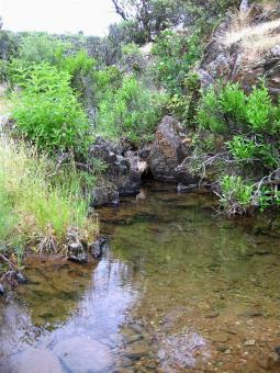
But the FB Trail is more than simply a long connector. It’s very enjoyable on its own, and it offers dazzling views of Keswick Reservoir. I’ve long thought of Keswick as little more than a debris pond, which, after all, is the reservoir’s purpose. But when viewed from the FB Trail, Keswick’s waters gleam like emeralds, and, depending on the sun’s angle, can provide magnificent reflections of the sky and hillsides. Plus, you get lake views for mile after mile, starting only about half a mile north of the Keswick Dam Road trailhead.

Unlike the Hornbeck, Lower Sacramento Ditch and Upper Sacramento Ditch trails, the FB Trail does not offer long stretches of virtually flat trail. Instead, the FB Trail rolls. The hills are neither long nor steep, but you’re going either up or down the entire way.
A side trail provides access to a seasonal waterfall (now dry) that many of us have been viewing for years from a bench on the Sacramento Rail Trail, located on the other side of the lake. There are also side trails to Eastshore Road and one route down to the lake itself.
The newest section of the FB follows a circuitous route from the ribbon bridge to Keswick Dam Road for nearly two miles in order to minimize the grade. The trail does not follow the old Nutter Butter mountain bike route, which is sort of unfortunate because that old dirt road offered a short but very fun descent. But steep trails can be an erosion nightmare and require a lot of maintenance. Thus, the more gentle slopes of the new trail. One other thing: Because this section of trail did not get built until so late in the season (trails are best built when there is some moisture in the soil), it is already extremely dusty.
Three other modest warnings about the FB Trail: Most of it is lined with straw to limit erosion. It’s evident to me that snakes love the straw mat, so keep an eye out. I’ve seen a beautiful California mountain kingsnake; I’ve also spotted a rattler. Second, there’s not a lot of shade on some sections, so consider avoiding the heat of the day. Third, the FB Trail was built with an average camber of 5 percent. If you’re on a mountain bike or horse, you’ll never know it. But if you’re on foot, you might notice. My feet and ankles sure felt the constant angle when I ran the length of the FB in each direction.
That slightly arched trail surface is necessary, local BLM trail guru Bill Kuntz said.
“That’s really the best way to build trails around here because of the amount of rain we get,” he said. “If you try to channel water, you end up with problems, erosion.”
If you’re headed north on the FB, the trail forks just short of the Hornbeck. The right fork is complete and connects with the Hornbeck about a mile and a half from the Hornbeck’s Quartz Hill trailhead. The left fork remains a bit rough and its intersection with the Hornbeck near the two-mile marker is not signed. The BLM plans to finish that section and do a few other touchups, but not until the next trail-building season.
The full Keswick loop, using the freshly paved rail trail (or gravel shoulder), Coram Road, Shasta Dam and the trails east of Keswick Reservoir, is about 38 miles. If you use the entire FB Trail and cross at the ribbon bridge – instead of following the road and crossing at the dam – you’ve got a full 40-mile loop.
Want to ride a mountain bike from, say, the Diestelhorst Bridge to Shasta Dam? Head up the bike path, jump on the FB Trail, hang a left on the Hornbeck and keep going north on the Upper Sacramento Ditch Trail. I figure it’s about 23 miles one way. Sweet.
Finally, the question on everyone’s mind. Who or what is FB? The answer is Francis Berg, the assistant field manager of the BLM’s Redding office who was instrumental is planning the trail and getting clearances from various agencies and landowners. Thanks, Francis.
 Paul Shigley is senior editor of California Planning & Development Report, a frequent contributor to Planning magazine and will be looking for the sag wagon well before 38 miles. He lives in Centerville. Paul Shigley may be reached at pauls.anewscafe@gmail.com.
